In the world of surveying, civil engineering, and construction, timing isn’t just a logistical detail—it’s a data-quality imperative. While most people view April as the season of renewal and blooming flowers, the seasoned professional looks at the landscape through a different lens: Line of Sight (LOS).
As we move into the heart of spring, there is a narrow, high-value window known as the “Leaf-Off” period. This is the brief interval after the winter snow has melted but before the spring “green-up” fully takes hold. For anyone utilizing 3D laser scanning or LiDAR technology, this is the most productive month of the year.
Here is why April is the “Golden Hour” for site documentation and why you should be deploying your Faro Focus, Topcon GTL, or Sokkia scanning solutions right now.
1. The Physics of the “Perfect 3D Laser Scan”
3D laser scanning is a “Line of Sight” technology. Whether you are using Phase-Shift or Time-of-Flight scanning, the sensor requires a clear, unobstructed path to the target to return a data point.
When a site is in “Leaf-On” status (mid-May through September), the dense canopy of deciduous trees and thick underbrush acts as a physical shield. The laser pulses hit the first leaf they encounter and bounce back. In a heavily wooded or overgrown area, this creates a “canopy shadow,” where the ground surface (the bare earth) is completely obscured.
The April Advantage: In April, the “skeleton” of the terrain is exposed. Without the foliage, your laser pulses can penetrate deep into wooded areas, capturing:
-
- Curb lines hidden by overhanging brush.
-
- Retaining wall heights obscured by ivy.
-
- Precise topography of embankments and ditches.
-
- The exact location of utility poles and pedestals tucked away in greenery.
By scanning now, you achieve a much higher density of ground points, which is the foundation of any accurate Digital Terrain Model (DTM).
2. Efficiency: Less “Noise,” Faster Processing
If you’ve ever tried to clean a point cloud captured in the middle of July, you know the struggle of “noise.” Thousands of points representing individual leaves, swaying branches, and tall grass must be filtered out to find the actual structure or ground underneath.
This filtering process is time-consuming and often requires manual intervention. Even the most advanced AI-driven “ground extraction” software can struggle to distinguish between a dense patch of weeds and a subtle change in grade.
A 3D Laser Scan in April means:
-
- Cleaner Raw Data: Your point cloud is dominated by hard surfaces and structural geometry rather than organic “fuzz.”
-
- Faster Registration: With clearer views of permanent structures and site features, your software can more easily “stitch” different scan positions together.
-
- Reduced File Sizes: You aren’t wasting gigabytes of data on temporary vegetation that will be gone or changed by your next site visit.
3. Capturing the “As-Built” Before the Earth Moves
April is often the precursor to major earthmoving and foundation work. Using 3D scanning during this window provides the ultimate baseline as-built. When you scan a site in its “raw” April state, you are capturing the truest representation of the existing conditions. This is critical for:
-
- Volumetric Calculations: Knowing exactly how much dirt needs to be moved starts with an accurate pre-construction scan.
-
- Utility Verification: Before the grass grows tall and the site gets muddy, you can clearly document the location of every manhole, valve box, and utility mark.
-
- Encroachment Checks: See exactly where a neighbor’s fence or a stray structure sits relative to the property line without having to hack through a summer’s worth of overgrowth.
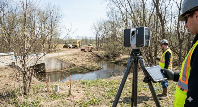
4. Precision in Infrastructure: Bridge and Highway Inspection
For those in the DOT or municipal sectors, April is the prime season for bridge and highway inspections. 3D scanning is revolutionizing how we monitor structural health, but the accuracy of a bridge scan is heavily dependent on seeing the “nodes”—the connections where beams meet piers.
In the summer, many rural bridges are engulfed in vines and trees. Attempting to scan a bridge abutment when it’s covered in Virginia Creeper is a fool’s errand. In April, those structures are bare. You can capture the concrete spalling, the steel corrosion, and the bearing alignments with sub-millimeter precision because the “skin” of the infrastructure is visible.
5. Leveraging the Right Tech: Topcon and Faro Solutions
To make the most of this April window, you need gear that can handle the variable spring weather and the demands of high-speed data acquisition.
-
- The Topcon GTL-1200: This is the ultimate “April Tool.” It combines a robotic total station with a high-speed laser scanner. You can perform your layout and your site scanning in one fluid workflow, ensuring your April “leaf-off” data is perfectly georeferenced to your project coordinates.
-
- The Faro Focus Premium: For those needing pure speed and portability, the Faro Focus allows you to move through a site quickly before the weather turns. Its high dynamic range (HDR) photography is particularly useful in the “flat” light of a cloudy April day, providing realistic color overlays to your point clouds.
6. The Risk of Waiting: The “Green Wall”
If you push your site documentation into May or June, you aren’t just dealing with leaves; you’re dealing with the “Green Wall.” Once the canopy closes, the amount of sunlight reaching the ground drops significantly. This can affect the quality of the internal cameras used for colorizing point clouds, leading to dark, muddy-looking data.
Furthermore, spring growth is rapid. A ditch that is clear and easy to scan on April 10th can be a 4-foot-high thicket of thorns by May 15th. The cost of clearing that vegetation—both in terms of man-hours and permitting—far outweighs the cost of mobilizing a scanning crew a few weeks earlier.
Summary: Your 3D Laser Scan April Action Plan
Don’t wait for the project to “ramp up” before you think about your data. The most successful firms are those that treat April as their Primary Acquisition Month. Steps to take this week:
-
- Audit Your Sites: Identify which upcoming projects have significant outdoor components or wooded areas.
-
- Check Your Calibration: Ensure your scanners are serviced and ready for high-volume use. (Precision is only as good as your last calibration!)
-
- Deploy Early: Schedule your scanning crews to hit the field before the first major “green-up” of the season.
At Topo Element, we provide the high-precision tools you need to capture the world exactly as it is—before the leaves get in the way. Whether you are looking to rent a scanner for a specific April project or upgrade your fleet to the latest Topcon or Faro technology, we are here to ensure your “Golden Hour” isn’t wasted.
The leaves are coming. Are you ready?
For more information on the latest 3D laser scanning hardware or to schedule a demo of the Topcon GTL-1200, visit our products page or contact our technical team today.