
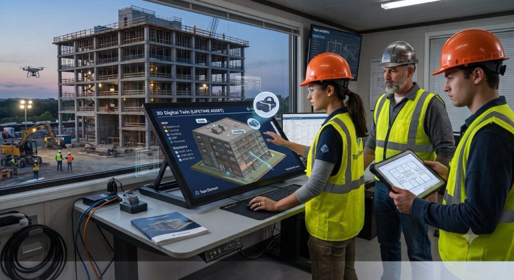
For decades, the standard deliverable in surveying and spatial documentation followed a familiar routine: a land surveyor or 3D scanning crew went out to a site, gathered millions of data points, and ultimately flattened all that rich physical reality into a static, 2D CAD drawing or PDF plan set.
While lines, arcs, and text callouts served the architecture, engineering, and construction (AEC) industries well throughout the 20th century, modern project demands have outgrown them. Today’s job sites are more complex, timelines are tighter, and project stakeholders expect an unprecedented level of clarity.
As a result, a major industry shift is taking place. General contractors, facility managers, property owners, and architects are no longer asking just for flat vector drawings. They are demanding 3D Digital Twins.
At Topo Element, we view this transformation not merely as a change in file formats, but as a total evolution in how physical assets are understood, built, and managed over their entire lifecycle.
Here is a closer look at what a Digital Twin actually means for local projects, how 3D laser scan data forms its foundation, and why moving beyond 2D CAD is the single best way to future-proof your next project.
What Actually Is a “Digital Twin”? (Demystifying the Hype)
The term “Digital Twin” gets thrown around constantly in tech circles, often leading to confusion. It can sound like a buzzword reserved for aerospace engineering or multi-billion-dollar smart cities. But for regional construction projects, commercial renovations, and facility management, the concept is far more grounded and practical.
A Digital Twin is a high-accuracy, spatially precise, dynamic 3D digital model of a physical asset that reflects its real-world conditions.
Unlike a static 2D CAD drawing—which represents a simplified, two-dimensional abstraction of a building or site at a single frozen moment in time—a Digital Twin provides a true-to-scale 3D representation containing rich geometric and spatial data.
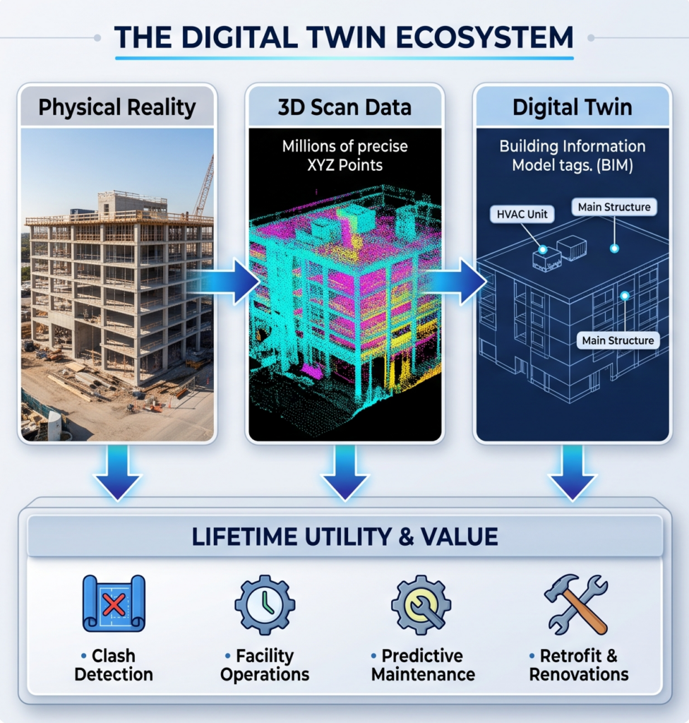
When built on the back of high-definition 3D laser scanning, a Digital Twin captures every conduit, structural beam, pipe run, and wall deviation down to millimeter-level accuracy. It creates a virtual single source of truth that anyone on the project team—from the chief architect in the office to the subcontractor on the field—can access, explore, and analyze.
Why 2D CAD Drawings Are Falling Short
To understand why clients are demanding 3D Digital Twins, it helps to look at the inherent limitations of traditional 2D deliverables:
-
- Information Loss in Translation: Flattening a complex, multi-layered 3D space into 2D lines inevitably leaves out critical geometric information. Missing a 2-inch pipe deflection on a flat plan can lead to major field clashes during mechanical installation.
-
- Interpretation Errors: 2D drawings rely heavily on human interpretation. If a contractor misinterprets a cross-section detail, work can easily come to a grinding halt while waiting for an RFI (Request for Information) response.
-
- Outdated Before Printing: By the time a set of 2D as-built plans is drafted, plotted, and delivered to the field, physical site conditions may have already changed.
-
- Siloed Utility: A 2D CAD file is primarily useful during design and initial construction. Once the keys are handed over to the asset manager or operations team, a set of printed blue sheets often ends up gathering dust in a basement storage room.
A Digital Twin solves these issues by providing an intuitive, interactive, and hyper-accurate platform that remains valuable long after construction crews pack up and leave.
The Foundation: How 3D Laser Scanning Powers the Twin
You cannot build an accurate Digital Twin on estimates or rough site measurements. A twin is only as good as the underlying spatial data used to construct it. This is where high-definition 3D laser scanning (LiDAR) becomes essential.
When Topo Element deploys field teams to a project site, our terrestrial laser scanners and mobile reality capture tools emit millions of eye-safe laser pulses per second. These pulses bounce off every exposed surface—walls, structural steel, concrete slabs, mechanical systems, and ambient topography—calculating precise X, Y, and Z coordinates for each point.
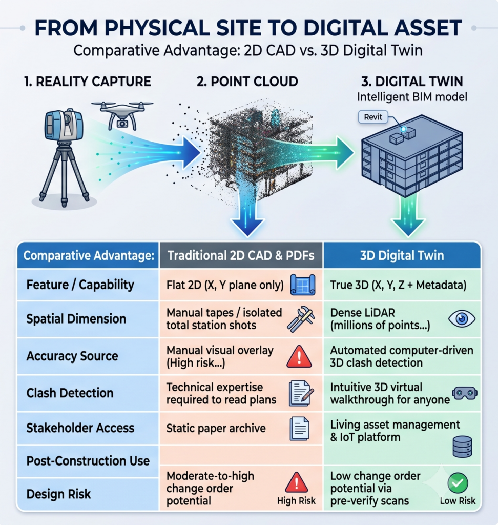
The result is a dense, colorized point cloud—a hyper-accurate 3D digital duplicate of the existing environment. From this raw scan data, we author intelligent Building Information Models (BIM) in software like Autodesk Revit.
These models don’t just show where a wall or pipe is located; they can hold metadata about component materials, installation dates, equipment model numbers, and maintenance schedules.
3 Game-Changing Use Cases for Digital Twins
Digital Twins bring practical value across every phase of an asset’s life cycle. Here are three primary ways our clients leverage them:
1. De-risking Renovations & Clash Detection
When retrofitting an existing building or upgrading industrial facility equipment, surprise field conditions are the leading cause of cost overruns and delays.
By capturing existing conditions as a Digital Twin prior to design, architects and engineers can drop proposed 3D design elements directly into the scanned environment. Software automatically performs clash detection, flagging exact spots where a new HVAC duct would collide with an unmapped structural beam before fabrication ever begins.
2. Virtual Walkthroughs & Remote Site Management
In an age of distributed teams and remote collaboration, bringing stakeholders to a physical job site can be costly and time-consuming.
A Digital Twin allows project managers, out-of-state owners, sub-contractors, and inspectors to take virtual, high-definition walkthroughs of a site from anywhere in the world. They can take real-time spatial measurements directly inside the browser, review site progress, and verify install accuracy without taking a single flight or site drive.
3. Lifetime Facility Management & Predictive Maintenance
The utility of a Digital Twin doesn’t end when construction wraps up—in fact, that’s often when its real ROI begins.
For facility managers and asset operations teams, a Digital Twin serves as a visual index for the entire building. Instead of hunting through thousands of pages of paper manuals or disjointed spreadsheets, a technician can click on a pump, valve, or air handler within the 3D model to access:
-
- Maintenance history and service logs
-
- Serial numbers and manufacturer warranty data
-
- Real-time sensor feeds (IoT integration) measuring pressure, temperature, or energy usage
-
- Concealed mechanical pathways inside walls or under slabs captured before drywall was installed
By pairing real-time IoT sensor data with the 3D model, facility leaders can transition from reactive repair strategies to predictive maintenance—fixing critical components right before they fail based on performance anomalies highlighted directly within the twin.
Comparative Advantage: 2D CAD vs. 3D Digital Twin
| Feature / Capability | Traditional 2D CAD & PDFs | 3D Digital Twin |
| Spatial Dimension | Flat 2D (X, Y plane only) | True 3D (X, Y, Z + Metadata) |
| Accuracy Source | Manual tapes / isolated total station shots | Dense LiDAR (millions of points per sec) |
| Clash Detection | Manual visual overlay (High risk of human error) | Automated computer-driven 3D clash detection |
| Stakeholder Access | Technical expertise required to read plans | Intuitive 3D virtual walkthrough for anyone |
| Post-Construction Use | Static paper archive | Living asset management & IoT platform |
| Design Risk | Moderate-to-high change order potential | Low change order potential via pre-verify scans |
Topo Element: Your High-Tech Spatial Data Partner
Transitioning from traditional 2D workflows to 3D Digital Twins requires more than just buying software—it requires a partner who understands spatial precision, ground-truth measurement, and how to manage massive reality capture datasets effectively.
At Topo Element, we view ourselves as far more than just a firm with high-end scanning equipment. We act as an extension of your technical team, helping you navigate the transition to modern reality capture. Whether you need high-density point clouds, fully modeled Revit BIM assets, or web-accessible 3D spatial models, we deliver tailored solutions built for your specific project outcomes.
Don’t let outdated 2D workflows introduce risk and friction to your next project.
Ready to elevate your next project with a Digital Twin?
Contact our team today to discuss how our modern 3D laser scanning services can help you capture accurate site reality, streamline design, and future-proof your valuable assets.