
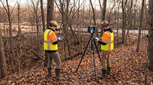
Earlier this year, we talked about the “spring leaf-off window” in April—that brief, crucial time when the winter snow has melted but before the spring “green-up” fills the landscape with dense foliage. If you missed that window, or if a new project just landed on your desk, we have good news: the second golden opportunity of the year is here.
As the late autumn days settle in, we are entering the Fall Leaf-Off window. For surveyors, civil engineers, and construction managers, this is a highly productive time for data capture. Once the autumn leaves drop but before the winter snowpack and heavy rains take over, the natural line of sight on heavily wooded or overgrown project sites is entirely cleared.
Here is why this second leaf-off window is the ultimate time to deploy 3D laser scanning, and how you can leverage it to get the cleanest, most accurate data of the year.
Why “Leaf-Off” Matters for 3D Laser Scanning
To understand why this window is so valuable, we have to look at the physical limitations of laser scanning.
Terrestrial 3D laser scanners (like the FARO Focus Premium or mobile FARO Orbis) and drone-mounted LiDAR operate on a “line-of-sight” principle. They emit millions of light pulses per second, which bounce off physical surfaces and return to the sensor to calculate distances and generate a 3D point cloud.
When you scan a site in the summer, those light pulses hit leaves, brush, and dense undergrowth. While advanced LiDAR can sometimes pierce through small gaps in a canopy, dense foliage acts like an impenetrable wall. The results are:
-
- Incomplete Ground Data: Your scanner captures the top of the brush, not the actual bare earth, creating massive “blind spots” on your topographic maps.
-
- “Noisy” Point Clouds: You end up with billions of data points representing leaves, twigs, and bushes, requiring hours of manual filtering and processing to find the true structures beneath.
-
- Slower Field Work: Crews have to move the scanner to dozens of extra positions just to “see” around heavy vegetation.
Once the autumn leaves fall, the landscape opens up. Suddenly, your scanner can capture the ground, rocky outcrops, utility features, and structures in a single pass.
The Key Advantages of Late Autumn Laser Scanning
1. Millimeter-Accurate Ground Topography (The Bare-Earth Advantage)
On heavily wooded, hilly, or overgrown sites, trying to get an accurate topographic map during the spring and summer can be a headache.
During the fall leaf-off, your scanners can see the actual terrain. For drone-based aerial LiDAR or terrestrial scans, the lack of canopy means that nearly every pulse hits the ground, rather than being absorbed or deflected by leaves. This allows you to generate highly accurate Digital Terrain Models (DTMs) and inspect grade changes, erosion, and drainage patterns without guessing what is under the brush.
2. Spotting Hidden Infrastructure and Boundary Markers
Over the course of a long spring and summer, utility poles, old foundations, retaining walls, and even property pins can become completely swallowed by brush.
When the foliage dies back and the leaves drop, this “lost” infrastructure is exposed. Running a 3D laser scan during this window ensures you capture accurate “as-built” data for hidden or hard-to-reach features. You won’t have to send crews into dense brush with machetes to locate a boundary marker or utility box—the scanner will capture it from a distance with ease.
3. Clean, Actionable Point Clouds (Less Office Back-End Time)
At Topo Element, we know that capturing data is only half the battle; processing it is where the real work happens.
Scanning a heavily vegetated site in the summer results in “dirty” data that requires extensive manual filtering to find the ground and structures. In late autumn, you are capturing bare earth, tree trunks, and structures without the “noise” of billions of tiny leaves. This means your point clouds are naturally cleaner, the registration process is faster, and you can convert your scan data into a BIM or CAD model in a fraction of the time.
4. Maximizing Line-of-Sight for Safer, Faster Scanning
With the foliage gone, the visibility on your jobsite increases dramatically. This has a direct impact on your scanning efficiency:
-
- Fewer Scan Setups: Since the scanner can “see” much further without obstruction, you can capture larger areas from fewer scan positions.
-
- Easier Target Registration: If you are using spheres or paper targets to register your scans, you won’t have to struggle to maintain a clear line of sight between them through the trees.
-
- Increased Crew Safety: Tripping hazards, steep drop-offs, and natural obstacles are visible, making the site safer for your crews as they move equipment.
Setting Up for Late Autumn Success: Tech You Need
To make the most of this fleeting window, your crew needs to be equipped with the right gear. Natural elements like fading light, damp ground, and morning frost will still be factors, but the right technology can help you capture and process data quickly.
Terrestrial Scanning: The FARO Focus Series
For high-precision, millimeter-level accuracy of structures, civil sites, or wooded areas, a static scanner like the FARO Focus Premium is invaluable. Because natural lighting is less of a factor in late autumn, the Focus can capture extremely dense, accurate point clouds even on overcast or late afternoon shoots. It’s rugged, fast, and allows for on-site registration, meaning you can verify that you have captured every inch of the newly exposed terrain before your crew leaves the field.
Mobile Scanning: The FARO Orbis Premium
If you are mapping large, wooded parcels, walking the site with a mobile scanner like the FARO Orbis Premium is a game-changer. Powered by SLAM (Simultaneous Localization and Mapping) technology, the Orbis allows your operator to capture accurate 3D data as fast as they can walk the terrain. Without leaves and brush blocking the paths, your team can cover miles of rugged, wooded, or hilly ground in a single day, capturing rich 3D data that would take weeks using traditional methods.
Aerial Mapping: Drone-Mounted LiDAR
If your projects involve large acreage, now is the time to get your drones in the air. Drone-mounted LiDAR becomes infinitely more effective during leaf-off. Without the dense summer canopy, drone sensors can penetrate straight to the forest floor, yielding unparalleled “bare-earth” accuracy that is nearly impossible to capture during any other season (except for the equally brief April window).
Don’t Wait Until the Snow Falls
The late autumn “leaf-off” window is highly productive, but it is also incredibly brief. In many areas, once the leaves are down, you have only a matter of weeks before the first major winter snows or heavy, muddy rains set in. Snowpack will mask the ground, change elevations, and make scanning outdoor terrain nearly impossible until the following spring.
If you have heavily wooded sites, upcoming civil projects, or as-built requirements, now is the time to schedule those scans.
Let Topo Element Help You Capitalize on the Window
At Topo Element, we are here to ensure you have the tools, support, and training to capitalize on this season.
Whether you need to upgrade your field capabilities with a new FARO Focus, rent a mobile Orbis scanner to quickly tackle a large parcel, or have your existing equipment calibrated and cleaned to handle the brisk autumn weather, our expert team in Southern California has you covered.
Don’t let the best scanning window of the year pass you by. Reach out to us today to discuss your upcoming projects, secure a rental, or schedule a hands-on, on-site demo of our 3D scanning solutions. Let’s get your data captured with the highest accuracy possible before winter takes over.
Key Takeaways for Your Team:
-
- Timing is Everything: Once the leaves drop, you have a brief, high-value window before winter weather obscures the ground.
-
- Superior Data: Fewer leaves mean less scanning “noise,” yielding incredibly clean point clouds and easier bare-earth extraction.
-
- Efficient Operations: Clearer sightlines translate to fewer scanner setups, faster mapping, and lower project costs.
- Choose the Right Gear: Terrestrial, mobile, and aerial solutions each offer unique advantages for leaf-off conditions. Bring the right tool to the site to maximize your ROI.