
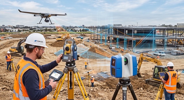
If there is one thing land surveyors, MEP trades, and general contractors know all too well, it is that capturing a job site is only half the battle. Over the last decade, hardware advancements have given us reality capture tools that are astonishingly fast. Modern 3D laser scanners and robotic total stations can blanket a site in millions of precise coordinate points in a matter of minutes.
But for years, that speed in the field created a massive bottleneck in the office. Processing those massive datasets—stitching scans together, cleaning out the “noise” of moving equipment and people, and manually tracing pipes and walls—often took days or even weeks.
In 2026, that narrative has completely flipped. Artificial Intelligence (AI) has officially transitioned from an overhyped industry buzzword into an indispensable, foundational tool for spatial data management. For the construction and surveying professionals, AI is fundamentally changing the way point cloud data is processed, analyzed, and delivered.
Instead of passive software that requires you to click your way through every action, we have entered the era of “Agentic AI”—intelligent processing systems that actively manage the heavy lifting. Let’s break down exactly how AI is revolutionizing point cloud processing and what it means for your next project.
The Core Challenge: Drowning in Spatial Data
To understand why AI is such a massive leap forward, we first have to look at the sheer volume of data modern reality capture generates. A single scan from a high-end terrestrial LiDAR unit can produce tens of millions of data points, representing a rich, 3D representation of existing conditions. A full day of scanning on a commercial construction site can easily result in hundreds of individual scans, yielding a point cloud containing billions of points.
Historically, this raw point cloud was incredibly difficult to use directly. It was essentially a “dumb” dataset—a highly accurate, three-dimensional photograph made of dots, but without any underlying context. The software didn’t know the difference between a load-bearing steel column, an HVAC duct, or a worker walking past the scanner.
Transforming this raw data into structured, usable Building Information Modeling (BIM) components or clean topographical maps required immense manual labor. Scan technicians had to visually navigate the point cloud, slice the data, and manually trace or fit geometric primitives (like cylinders and planes) to represent real-world objects. This workflow was tedious, prone to human error, and expensive.
AI solves the “data drowning” problem by giving the software the ability to actually understand what it is looking at.
AI-Driven Auto-Registration: The End of Target Hunting
The first major hurdle in any reality capture workflow is registration—the process of taking dozens or hundreds of individual scans and accurately stitching them together into a single, cohesive master point cloud.
In the past, this meant field crews had to painstakingly place checkerboard targets or spheres throughout the site. The software would then hunt for these common targets in overlapping scans to calculate the alignment. If a target was bumped, obscured, or placed too far away, the registration failed, forcing the office technician to manually drag and drop scans into place.
Today’s AI algorithms, built into processing platforms like FARO SCENE and cloud-based environments like FARO Sphere XG, have virtually eliminated the need for artificial targets.
Machine learning models evaluate the geometry of the scans themselves—identifying intersecting planes, corners, and unique structural signatures—to automatically align the data. These AI-driven systems don’t just guess; they perform complex quality checks, detecting early signs of registration drift and correcting alignment errors in real-time.
Furthermore, AI handles the tedious task of data cleanup. Modern algorithms automatically detect and filter out “ghosts” and noise—such as passing vehicles, dust, or moving workers—ensuring that the final registered point cloud is incredibly clean and crisp before any modeling even begins. This dramatically accelerates the field-to-office pipeline, meaning field crews spend less time placing targets and office teams spend zero time cleaning up artifacts.
The Magic of Agentic AI and Feature Extraction
Once the point cloud is registered and cleaned, the real magic of 2026 software comes into play: automated feature extraction. This is where “Agentic AI” proves its worth.
Rather than waiting for a human to tell it what to do, Agentic AI acts as an autonomous assistant. It utilizes advanced deep learning models—including Convolutional Neural Networks (CNNs) and transformer models using voxel-based processing—to parse through billions of unorganized points and classify them.
The AI automatically segments the point cloud, separating architectural and structural elements from the surrounding environment. It can instantly identify walls, floors, ceilings, columns, beams, pipes, and electrical conduits.
-
- For the MEP Contractor: The software can look at a complex mechanical room scan, recognize cylindrical point clusters as piping, determine their exact diameter, and automatically extract them as standardized 3D pipe objects ready for Revit or CAD.
-
- For the Civil Engineer and Surveyor: AI can strip away dense vegetation from a topographic scan, automatically generating a highly accurate bare-earth digital terrain model (DTM) without hours of manual point classification. It automatically extracts planimetric features like curbs, road edges, and utility covers.
This level of automation replaces hours—sometimes days—of manual tracing and interpretation. It is not just about speed; it is about consistency. Because the AI applies the same extraction logic across the entire dataset, it reduces the subjectivity and human error inherent in manual drafting.
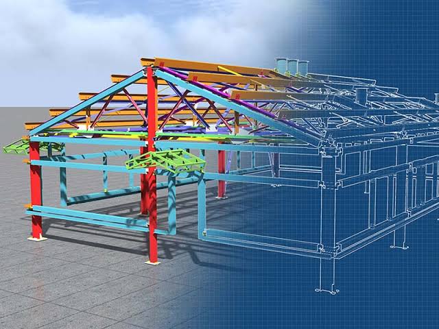
AI segments point clouds by feature, turning raw points into actionable BIM models.. Source: Terrain Survey
AI for Real-Time QA/QC and Deviation Analysis
Perhaps the most valuable application of AI point cloud processing for general contractors in 2026 is automated deviation analysis and Quality Assurance/Quality Control (QA/QC).
Construction is a constant battle between what was designed and what was actually built. Catching a mistake early—like an HVAC sleeve poured in the wrong place or a structural column slightly out of plumb—costs a fraction of what it takes to fix it weeks later after other trades have already built around it.
AI bridges the gap between the physical site and the digital design. Modern software platforms can automatically ingest the as-built point cloud data and overlay it directly onto the federated BIM model.
The AI then performs a highly detailed deviation analysis. It doesn’t just show a visual clash; it highlights specific areas where the built conditions differ from the design. If a newly framed wall is two inches out of plumb, or a concrete slab is poured half an inch too low, the AI instantly flags the discrepancy. It documents these deviations with precise measurements, providing the project management team with objective, undeniable data to address the issue with subcontractors before it derails the schedule.
In 2026, we are also seeing these AI algorithms process real-time data. With connected environments—such as cloud integrations and FARO’s latest updates—point cloud data can be captured via drone or terrestrial scanner, uploaded directly from the job site, and processed by cloud-based AI. The project manager can have a complete QA/QC deviation report on their tablet before the scanning crew has even packed up their gear.
The Economics: What AI Means for Your Bottom Line
When you strip away the technical jargon, the true value of AI in point cloud processing comes down to economics. It fundamentally shifts the cost structure of reality capture.
-
- Massive Reduction in Labor Hours: The most expensive part of a Scan-to-BIM workflow has traditionally been the human hours spent staring at a screen, tracing points. By automating registration, cleaning, and feature extraction, AI allows your CAD and BIM teams to focus on high-value design and coordination work rather than tedious data entry.
-
- Faster Turnaround Times: In construction, time is quite literally money. The ability to move from field capture to a finalized 3D model or QA/QC report in a matter of hours, rather than weeks, allows project teams to make critical decisions without delaying the schedule.
-
- Risk Mitigation: The automated deviation analysis provided by AI acts as an incredible insurance policy. By catching construction errors immediately, general contractors avoid costly rework, schedule overruns, and potential litigation.
-
- Scalability: With AI handling the data processing bottleneck, surveying firms and construction companies can take on larger, more complex projects—and more of them—without needing to proportionally scale up their drafting and modeling staff.
The Future is Already Here
The integration of Agentic AI into point cloud processing software isn’t some distant promise on a tech roadmap; it is the reality of how top-tier firms are operating right now in August 2026. The companies that are embracing these automated workflows are delivering more accurate data, turning projects around faster, and bidding more competitively than those still relying on manual processing.
At Topo Element, we understand that hardware and software have to work in perfect harmony to deliver these results. Whether you are looking to upgrade to the latest AI-enabled processing platforms or need the precision hardware from FARO, Sokkia, or Topcon to capture the data in the first place, we have the expertise to build your perfect workflow.
Ready to see how fast point cloud processing can really be? Reach out to our team at Topo Element today to schedule a demo and bring your reality capture into the AI era.